Where does Route 66 end? That really depends on what direction you are traveling, but for this article, I’ll be using the traditional western terminus as the ending point. The short answer to where Route 66 ends is the intersection of Lincoln and Olympic Boulevards in Santa Monica, CA. But depending who you ask it gets a little more complicated. In this article, I’m going to look at four endpoints to Route 66, the original end, the actual end, the symbolic end, and the traditional end.
The Original End
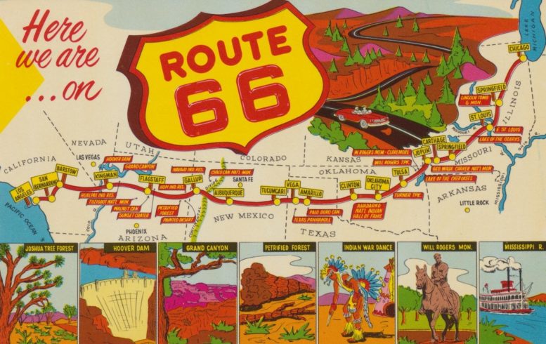
U.S. Route 66 or U.S. Highway 66 (US 66 or Route 66), which is also known as the Will Rogers Highway, the Main Street of America, and the Mother Road, was one of the original highways in the U.S. Highway System. Route 66 was formally established on November 11, 1926, running from Chicago, IL to Los Angeles, CA.
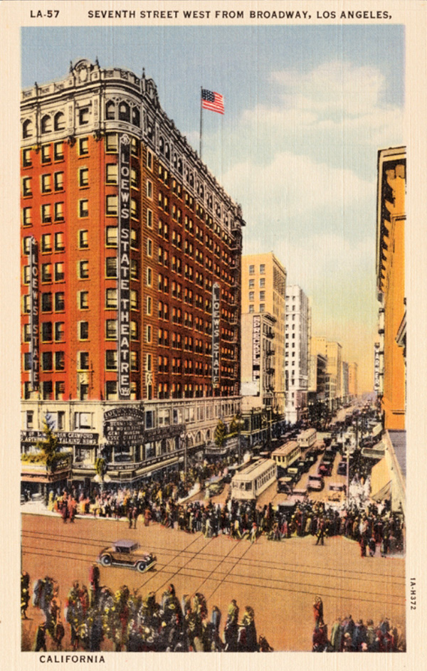
When Route 66 was established, the western terminus was located at 7th and Broadway in Downtown Los Angeles, CA, which at the time was one of the busiest intersections in the world, with an estimated 504,000 people crossing every day in 1924.
This would remain the western end of Route 66 until 1936 when the Route was extended further west to Santa Monica.
There is now a sign at the intersection marking 7th and Broadway’s place in Route 66 history.
The Official End
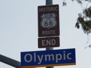
On January 1, 1936, Route 66 was officially extended from 7th and Broadway in Downtown Los Angeles, CA to Lincoln and Olympic Blvds. in Santa Monica, CA.
The intersection is about a mile from the Pacific Ocean, but Federal Highway rules stated that all highways could only end where there was another highway so that no travelers would be “dead-ended.”
After driving all the way to the end of Route 66, a lot of travelers kept on going towards the ocean once hitting this less than scenic spot.
Currently, there is a sign marking the end of Route 66 at the intersection. There is also a Mel’s Diner at the intersection, in the historic Penguin Coffee Shop building. The Penguin sign has even been converted into a Mel’s sign and retained its original look.
The Symbolic End
With the official end of Route 66 being about a mile from the ocean, lots of travelers just kept on going until they hit the Pacific. Their journey would usually take them down Santa Monica Blvd until it ended at Ocean Avenue, with the Pacific right in front of them.
When Will Rogers died, Route 66 adopted the nickname the Will Rogers Highway, and a plaque signifying Route 66 as the Will Rogers Highway was placed at Ocean and Santa Monica in 1952, leading to further confusion of the endpoint.
As this was about as far west as you could go, it became the symbolic end of the road.
The Will Rogers plaque is still located at this location as is another sign marking the end of Route 66 at the small visitors center.
The Traditional End
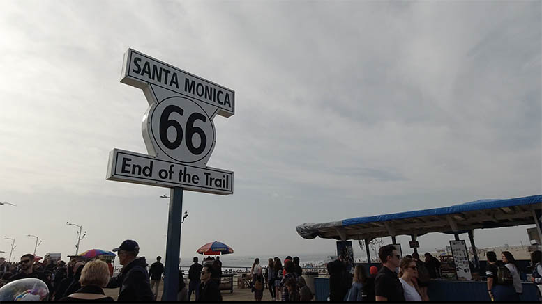
When most people picture the end of Route 66 in their mind, the image that comes up is probably the End of the Trail sign on the Santa Monica Pier. That shows the power of great marketing, as the sign was not put in that location until 2009.
In 2009, the Route 66 Alliance partnered with the Santa Monica Pier Restoration Corporation and declared the Santa Monica Pier to be the end of Route 66. With those pesky Federal Highway rules not applying to decommissioned highways, why not? It is certainly an interesting place to start or end a journey.
The End of the Trail sign was supposedly a leftover movie prop from the early 1930s and actually stood for years at the intersection of Ocean and Santa Monica. Part of the deal that named the Santa Monica Pier as the end of Route 66 also led to a recreation of that sign being installed at the pier. Now people line up to take their pictures with the sign.
If you travel past the End of the Trail sign down the pier, you will come to the 66toCali shop, which is filled with Route 66 souvenirs, and a tribute to the artist Bob Waldmire, who is the artist that is probably most closely associated with Route 66.
A few hundred more feet past the shop, you’ll come to the end of the pier and as far as you can possibly travel west without a boat, Route 66 or not.
Addendum
It must be noted that, while not in the scope or spirit of this article, Route 66 briefly ended at the intersection of Arroyo Parkway and Colorado Blvd. in Pasadena, CA in the 1960s after the interstate system replaced it in Los Angeles. Then, in 1975, after the interstate was completed in California, the end of Route 66 was officially moved to the California and Arizona border, where it stayed until Route 66 was officially decommissioned in 1985.