On a recent trip to Utah, I was looking at a map of our route and realized that we should be traveling pretty close to the state’s geographic center. Since we’ve been to a number of centers of states already, I figured this is a great chance to knock another off the list. Getting to the center of Utah ended up being quite the adventure.
How Many Centers Does Utah Have?
The first challenge we had was several places claiming to be the Center of Utah. Figuring out the center of the state can be challenging, especially since Utah has an odd shape, and depending on the method used, you can get different results.
In the 1920s, the U.S. Geological Survey came up with a list of geographical centers of every state. Then in 2015, they came out with a new list, and for most states the center moved. Though in the 1920s, the method they used to determine the centers was to suspend a cardboard cutout of the state by a string and then draw a vertical line from the suspension point.
Then, of course, there are a few places that just claim to be the center.
Levan, Utah
The story goes that Levan is “navel” spelled backward and was given that name because the town is near the center of Utah. The Utah place names book calls into question that origin of the town’s name, however. Going off the USGS’ listing for the center of Utah, Levan is about 20.5 miles away from the center, with the San Pitch Mountains in between.
Mt. Pleasant, Utah
Mt. Pleasant is called “Utah’s Hub City” due to its closeness to the center of the state. The city even has a marker designating where the center of the state is on Main St. According to the USGS however, Mt. Pleasant is about 19 miles from the geographic center.
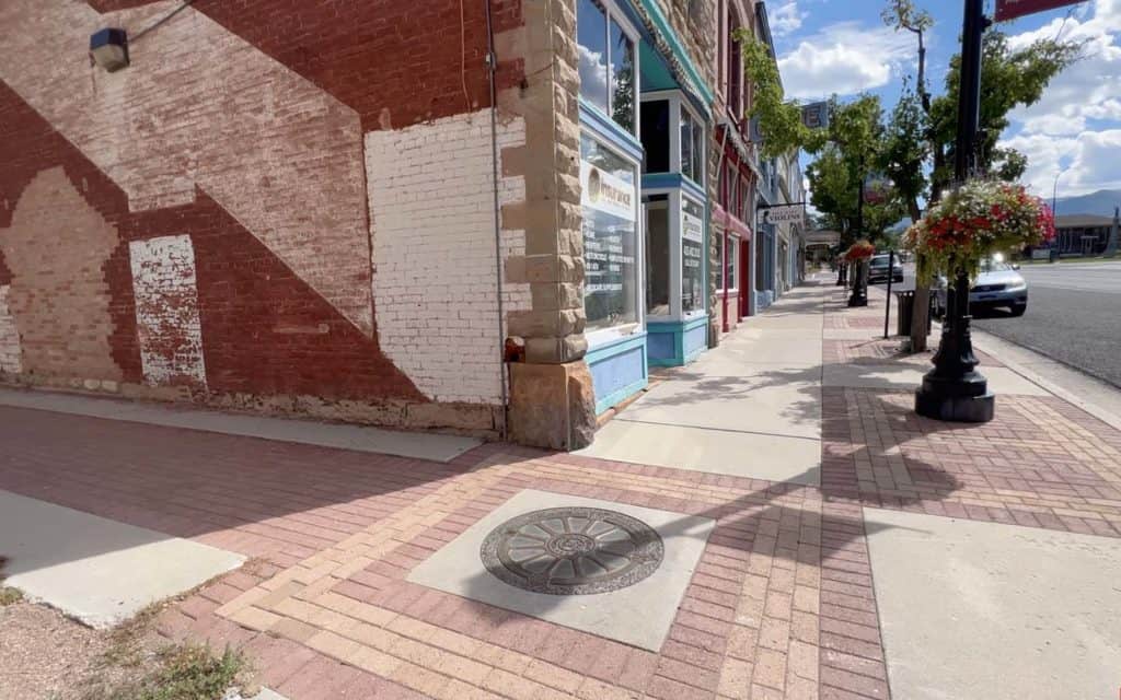
Just to be on the safe side, though, we did stop at Mt. Pleasant and visit their center of the state marker. The whole town was wonderful and really nice to walk around.
Spring City and Chester, Utah
I’ve been told some people claim Spring City or Chester as the state’s center too. I couldn’t find any public claims of either of them being the center anywhere. The USGS data shows Ephraim is the closest town to the center.
The Geographic Center of Utah
Back in 2008, an Eagle Scout from Mt. Pleasant named Jesse Richmond also wondered where the exact center of his state was. He contacted the USGS, and they gave him the exact coordinates.
Not being satisfied with just knowing where the center was, he set off to visit it. So he headed out with his GPS, found the exact coordinates, and set some rocks there. Richmond then worked to get donations and installed a permanent monument at the center along with his Eagle Scout troop.
A location confirmed by the USGS and a marker there? That sounds as close to official as you can get, so that’s where we decided to go.
Getting to the Center of Utah
We started our journey to the Geographic Center of Utah in Ephraim, which is located on Highway 89. That is pretty much the only way you can get to the center.
The first part of the journey is pretty easy. In Ephraim, you take W 100 N until it turns into Ephraim River Lane. Then things start to get a little more complicated.
After traveling down Ephraim River Lane for about 3.6 miles, you make a right on N W Side Rd, which is a dirt road with no street sign for it. It helps to be using a navigation app such as Google Maps. About a half mile later, you make a left on West Side Rd.
West Side Rd. becomes N. Manasses Rd. Follow N. Manasses Rd., and it will eventually make a couple of left turns, and you will find yourself at a gate.
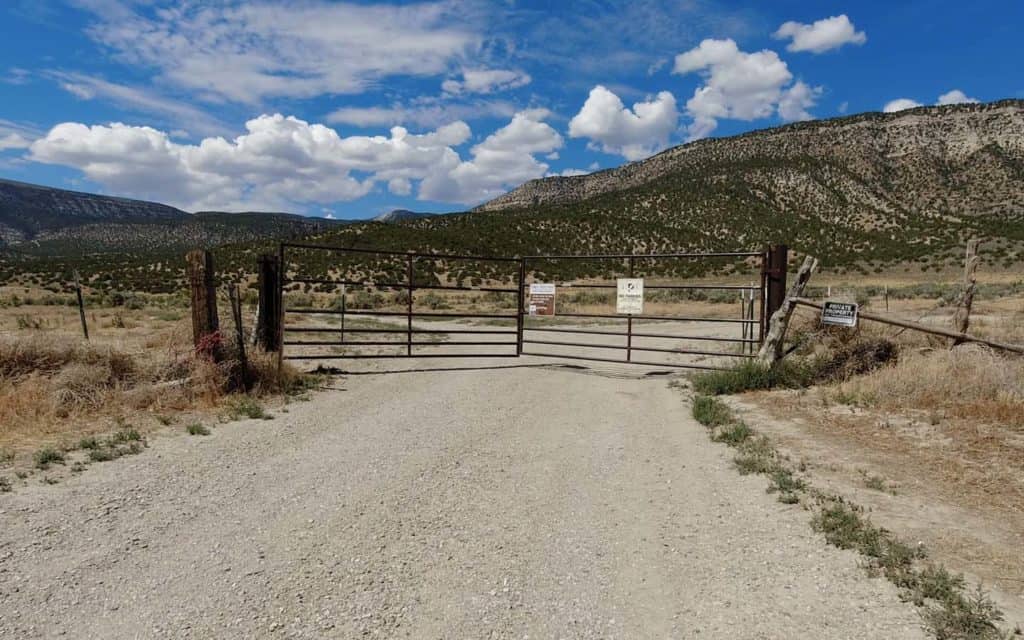
Luckily the gate isn’t the end of the road, as this is a public access road, so you can continue on. Just make sure to shut the gate after you go through. The nice smooth dirt road is no more, though; you will want a high-clearance vehicle going forward. Four-wheel drive may be necessary depending on the current conditions, but we didn’t need it on our journey. There is no way we would have made it without high clearance, though.
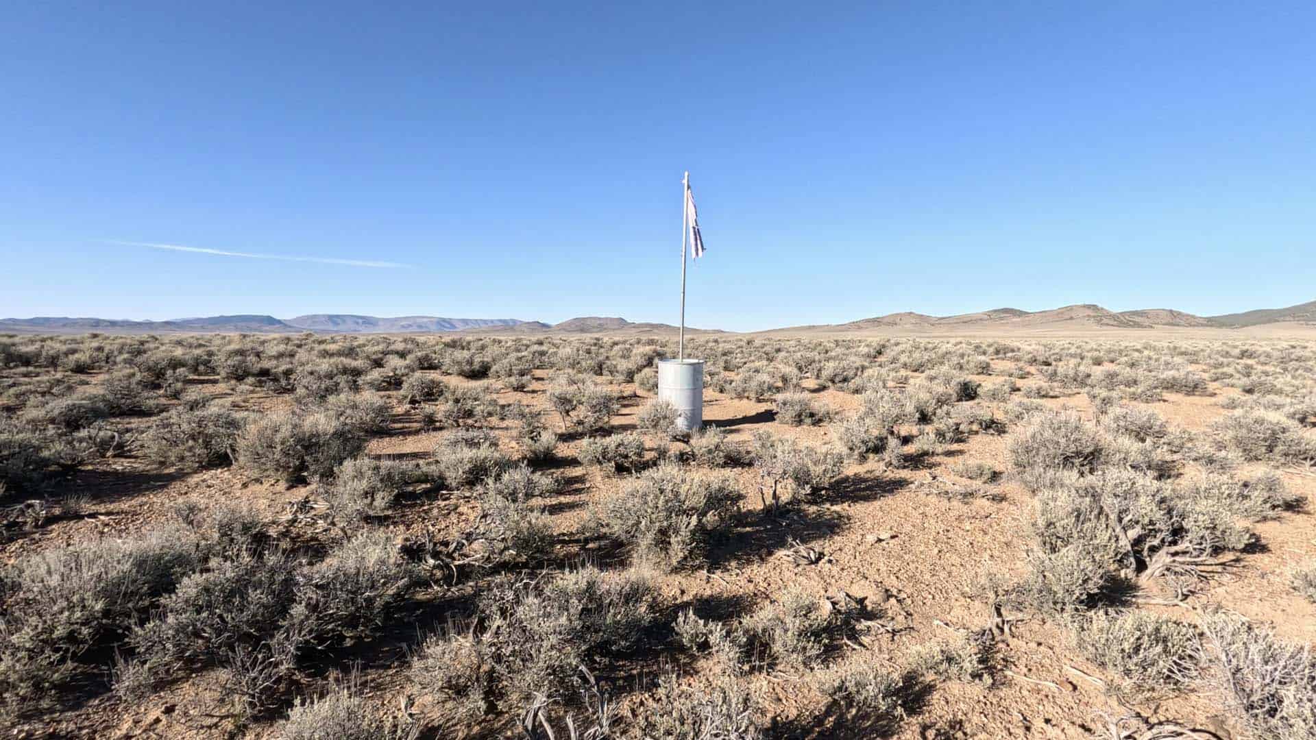
After going through the gate, you will want to stay to the left and continue on for a little under a mile until you come to a place where you want to make a sharp turn to the right. After a couple of hundred feet, you will see what looks like a turn-around. Park there and get ready to hike up a steep hill.
The Hike
There are no signs for the trail or the Geographic Center of Utah where the trail starts, but it is pretty obvious where the trail is as it is marked with rocks along the way.
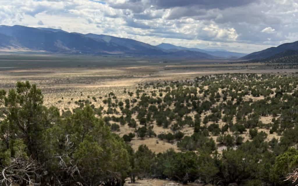
The trail starts out very steep but flattens towards the end. The total trail is only about a quarter of a mile long, but the steepness at the start and the fact that it starts at an elevation of 5,721 feet make it seem longer than it is. The trail gains about 150 feet or so in elevation.
You will know you are at the end of the trail when you come across the Geographic Center of Utah Monument.
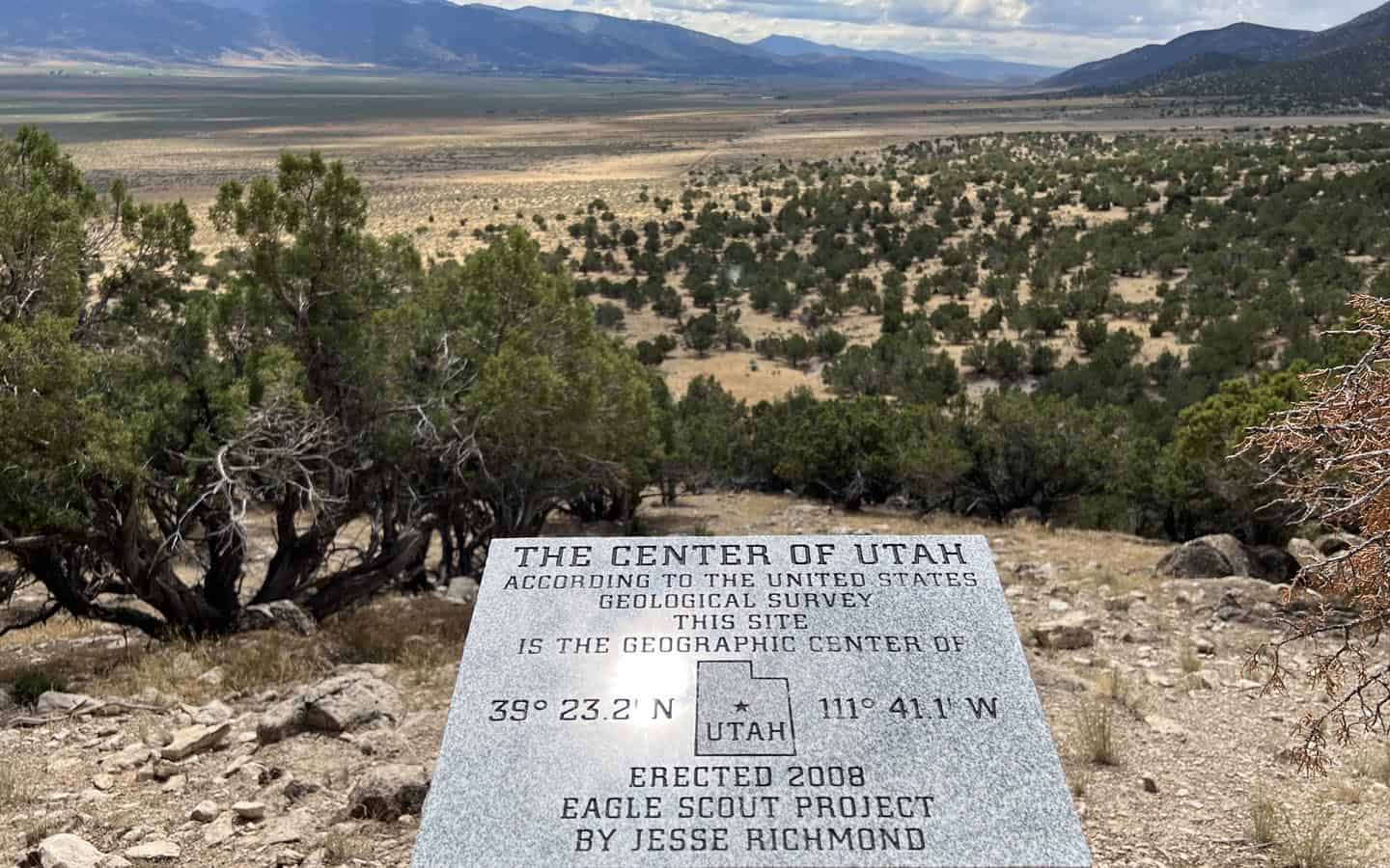
At the Geographic Center of Utah
After the not-so-long but exciting journey, we were rewarded with the stone monument that was put there by Jesse Richmond and his Eagle Scout Troop and some pretty nice views of the valley below.
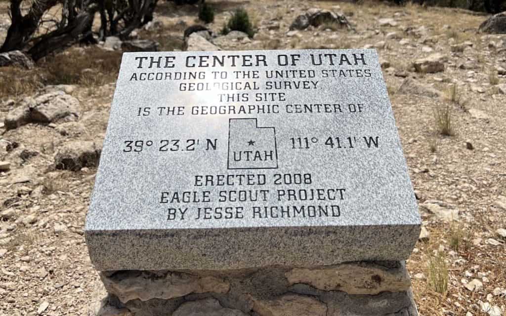
The monument says:
THE CENTER OF UTAH
According to the United States Geological Survey this site is the geographic center of
39 23.2 N Utah 111 41.1 W
Erected 2008
Eagle Scout Project
By Jesse Richmond
We brought a snack, and the end of the trail was an excellent place to enjoy it while taking a look at the view before heading back the way we came. In all, getting to the Geographic Center of Utah was a pretty fun trip, not difficult but a bit of an adventure.
GPS coordinates for the Geographic Center of Utah: N 39 23.200 W 111 41.100
If you’re interested in these kinds of places, we’ve visited other state geographic centers too. You can find them all here.